
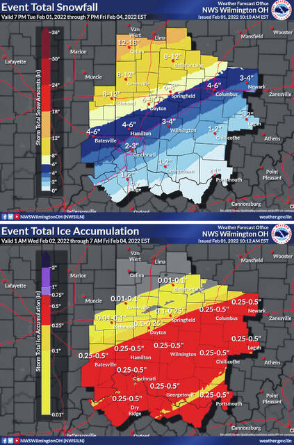

WILMINGTON — Clinton County and surrounding areas will be under a Winter Storm Watch beginning at 9 p.m. Wednesday through 7 a.m. Friday.
The forecast as of Tuesday afternoon by the National Weather Service office in Wilmington calls for:
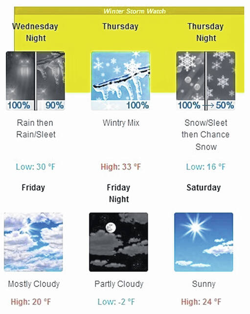
Wednesday
Rain, mainly after 10am. High near 44. South wind 9 to 13 mph. Chance of precipitation is 100%. New precipitation amounts between a half and three quarters of an inch possible.
Wed. p.m./
Thurs. a.m.
Rain before 5 a.m., then rain and freezing rain, possibly mixed with sleet. Low around 27. Light and variable wind becoming north 8 to 13 mph after midnight. Chance of precipitation is 100%. New ice accumulation of less than one-tenth of an inch possible. New sleet accumulation of less than a half-inch possible.
Thursday
Freezing rain and sleet before 3 p.m., then sleet, possibly mixed with snow. The sleet could be heavy at times. Patchy blowing snow after 5 p.m. High near 30. Blustery, with a northeast wind 15 to 20 mph, with gusts as high as 31 mph. Chance of precipitation is 100%. New ice accumulation of 0.1 to 0.2 of an inch possible. New snow and sleet accumulation of around an inch possible.
Thursday night
Snow, possibly mixed with sleet, becoming all snow after 7 p.m. Patchy blowing snow between 8 p.m. and 11 p.m. Low around 14. Blustery, with a north wind 16 to 20 mph, with gusts as high as 30 mph. Chance of precipitation is 100%. New snow and sleet accumulation of 1 to 2 inches possible.
Friday
A slight chance of snow before 9 a.m. Mostly cloudy, with a high near 22. Chance of precipitation is 20%.
Friday night
Partly cloudy, with a low around -4.
Saturday
Sunny, with a high near 24.
Saturday night
Mostly clear, with a low around 11.
Sunday
Mostly sunny, with a high near 34.
Sunday night
Mostly cloudy, with a low around 17.
Monday
Partly sunny, with a high near 32.

