
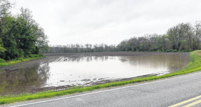


WILMINGTON — While it feels as if Clinton County has been under water for the past three days, it could be worse — just go a bit north … or west … or south of here and you’ll see.
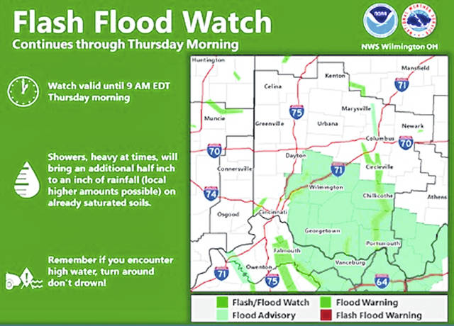
“Here in Clinton County we’ve had two to three inches of rain in the past 48 to 72 hours, which is quite a bit, but some of the surrounding areas have received about double that,” Meteorologist Kristen Cassady at the National Weather Service in Wilmington told the News Journal Wednesday morning.
“Closer to Columbus they’ve gotten from four to five inches in the past 72 hours, parts of Cincinnati and Butler and Warren counties four to six inches, and part of Northern Kentucky four to six inches.”
The NWS issued a Flash Flood Watch for many Southwest Ohio and Northern Kentucky counties earlier in the week, and that continues through Thursday morning “because we’re continuing to see rain,” said Cassady.
“It’s lighter in nature, but we’ll have on and off rain throughout the next 24 hours or so; there’s not a chance to completely dry out as the rain moves in from time to time.”
During a Flash Flood Warning, the NWS advises, “People in the watch area should keep an eye on the weather and be prepared for immediate action should heavy rains and flooding occur or a Flash Flood Warning be issued. Avoid low-lying areas, and be careful when approaching highway dips and underpasses.”
As for the immediate forecast, the NWS states, “Additional showers, possibly heavy at times, can be expected to continue Wednesday into Thursday. This additional rainfall on already saturated soils will allow for the flooding threat to continue.”
Showers are possible into early Friday, with sunshine and higher temperatures in the weekend forecast.
More in Midwest
Two breached dams caused by several days of rainfall and rising water on Tuesday forced the evacuation of about 10,000 people in mid-Michigan, where the governor said one downtown could be “under approximately 9 feet of water” by morning.
For the second time in less than 24 hours, families living along two lakes and a river were ordered Tuesday to leave home.
The National Weather Service issued a flash flood watch for locations along the Tittabawassee River after the breach at the Edenville Dam in Midland County, about 140 miles (225.31 kilometers) north of Detroit and the Sanford Dam, about seven miles (11.26 kilometers) downriver from Edenville.
“Extremely dangerous flash flooding is ongoing along the Tittabawassee River in Midland county due to catastrophic dam failures at the Edenville and Sanford dams,” the weather service said on its website, noting that anyone near the river should seek higher ground immediately, be prepared for immediate evacuations, and not drive into flooded roadways. “This flooding will continue all along the length of the river in Midland county, and possibly extending into Saginaw county where a Flash Flood Watch is also in effect.”
Michigan Gov. Gretchen Whitmer late Tuesday declared a state of emergency for Midland County and urged residents threatened by the flooding to evacuate the area. She said shelters have opened across the county and are available to residents who need a place to go.
Whitmer said downtown Midland faced an especially serious flooding threat. “In the next 12 to 15 hours, downtown Midland could be under approximately 9 feet of water. We are anticipating an historic high water level.”
The evacuations in Michigan followed days of heavy rains in parts of the Midwest that also brought flooding to Chicago and other parts of Illinois, Ohio and other states.
Edenville Dam holds back Wixom Lake. Officials also were watching the Sanford Dam south of Edenville. The city of Midland, which includes the main plant of Dow Chemical, sits on the banks of the Tittabawassee River about 8 miles (12.87 kilometers) away from that dam.
Dow Chemical Co. has activated its emergency operations center and will be adjusting operations as a result of current flood stage conditions, spokeswoman Rachelle Schikorra said in an email.
In Chicago, water that flooded some areas downtown was receding on Tuesday, but Larry Langford, a fire department spokesman, said that he did not expect power to be restored at the iconic Willis Tower for days because the rains caused the building’s subbasements to fill with as much as 25 feet (7.6 meters) of water. The building was closed to tenants and visitors.
The Associated Press contributed to this story.


